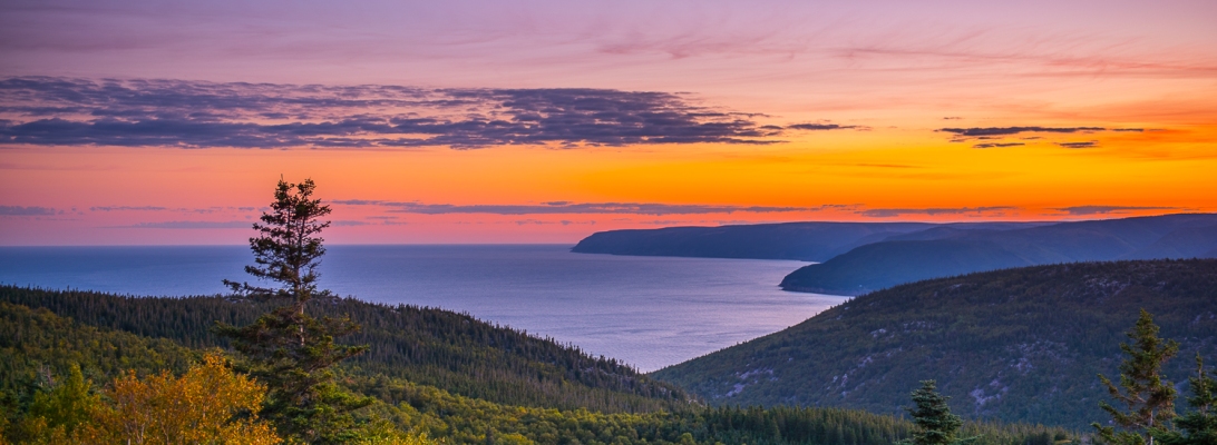
Jutting out into the North Atlantic Ocean; one of the furthest reaches of North America is also one of its crown jewels. Here is a place where land meets sea in a way that is unmatched by any place southward.
Sunrise glow above the MacKenzie River Canyon
Waterfall in the Aspy Valley
Looking North across the Gulf of St. Lawrence
The most famous section of the “World Famous” Cabot Trail
Forests that are bright green in summer come ablaze in autumn before becoming cloaked in white in winter. The French were the first to settle this land, eking a living off the bountiful seas teaming with cod and lobsters. Later came Anglos, who notwd its resemblance to Scotland. This landmass is where the province Nova Scotia (New Scotland) gets it name from. And by listening to local accents, one might think that you were still on the other side of the pond. Today the island hosts the world’s largest Celtic music festival.
Our short stay on the island was focused around the dramatic Western side of the Cape Breton Highlands National park. Here, the mountains jut 500m out of the sea. Along with the differing elevations are differences in climate. Mixed hardwood and spruce Acadian forests cling to the hillsides, while Boreal spruce forests dominate the headlands. In some places, Taiga dominates, mimicking landscapes found in Labrador and Northern Quebec.
A cloud bank rolling oin off of the Gulf of St. Lawrence creates a surreal fog atop the highlands
The Boreal forest floor begins to show the colors of autumn
the Skyline Trail is cape breton Highlands national Park most popular trail for good reason
Bountiful ocean harvest
“Beach Bungalow”
Sunset glow on the headlands
late afternoon sun on the Trans Canada Highway
A waterfall cascades into the Atlantic Ocean
Sunrise over Sydney Harbour from the Newfoundland Ferry
Alexander Graham Bell National Historic Site over looking Lake Bras D’ Or
Porpoises in the strait separating Cape Breton Island from the mainland
Fishing boats in Cheticamp Harbour beign stored for the winter season
Long exposure sunset along the shore of the Gulf of St. lawrence
This past weekend, my wife and I hit the road on a day trip to explore Douglas Point–an unexpected treasure that you likely won’t find in your DC guidebooks.
After scarfing down some delicious local BBQ at George’s BBQ in Indian Head, we arrived to dense mixed forests cloaked in brilliant autumn colors. Despite this beauty, we pretty much had the area to ourselves. Although we were within a 75-mile radius of DC, I could set a tripod in the middle of the road for ten minutes without a passing car. The colors alone are worth the trip, but the real hidden gem is Mallows Bay.
Kayakers exploring one of the many shipwrecks in Mallows Bay
Mallows Bay is a small bay on the Maryland side of the Potomac River in Charles County, Maryland. It is a unique recreation area resulting, in part, from abandonment and maligned plans. It is regarded as the largest shipwreck fleet in the Western Hemisphere and is described by many as a “ghost fleet”. How did this come to be in the Potomac? More than 100 of the vessels are wooden steamships, part of a fleet built to cross the Atlantic during World War I. However, most of these ships were obsolete upon completion since the war had ended. The US Government sent these vessels to Mallows Bay to be destroyed–and today the bay has evolved into a beautiful recreation area where visitors can tour the remains by walking the shoreline (like we did) or by paddling around the ship graveyard. We will be back with kayaks one day!
Douglas Point, a US Bureau of Land Management site, sits along a quiet road and sports beautiful mixed hardwood and pine forests–a rarity in the DMV region.
We then headed to the Douglas Point Recreation Area, managed by the US Bureau of Land Management (BLM). Although BLM is the largest landholder in the western United States, this is one of only a few sites on the east coast so it was certainly an unusual discovery in Maryland! Originally slated to become a nuclear power plant, public outcry resulted in the local electrical utility abandoning its plan, and eventually in the land’s public acquisition. The recreation area exceeded expectations. In the same afternoon, we toured the ruins of a 17th century home and walked the sandy Potomac shore in search of fossilized sharks teeth dating back 58 million years (we found one!). Given the beauty of this site, I’m glad that it is now protected from further development.
A picture of a swamp: it’s not a bad picture, but compared to my numerous other pictures of swamps, it may not look like much at first. However, this piece is the result of over a year’s worth of research, obtaining access to private property, crawling over boulders, trudging through wetlands, and numerous cuts/scrapes/wet boots.
What’s so special about this image is not the composition, lighting, or other photographic qualities. Instead, as I’ve been working on my book about the Potomac River, I’ve been trying to highlight all of the unique aspects of this watershed, namely the plants that call it home. Particularly, I’ve been searching for a naturally growing bald cypress, to demonstrate how the Potomac watershed houses so many unique plant communities.
The bald cypress, is a beautiful tree (used ornamentally in many locations, including in LaFayette Square next to the White House) that grows naturally in the swamps of the Southeastern US. Despite being a hardy plant, its seedlings cannot survive the winters endured North of here.
Sure, I’ve shot much more visually interesting images of this tree in the Great Dismal Swamp and Louisiana Cajun Country, but I want to convey how much the Potomac is at the juxtaposition of the American natural landscape. Travelling down the 302 mile long River is “biologically” equivalent to the 1500 mile journey from the Gulf of Mexico to the Bay of Fundy.
A stand of Loblolly Pines grows on Virginia’s Northern Neck. A tree common to the deep South, it is at the extreme northern edge of its natural range here.
Descending from the upland hardwood forests to the lower wetland forest at Westmoreland State Park in Virginia
A canopy of Tupelo Trees is emblazoned in fall colors.
After you visit somewhere, you’re supposed to check it off of your bucket list. However, every once in a while you find somewhere with so much depth and so much to see that you feel that in order to truly experience it you have to spend at least a month there, seeing numerous sights and getting to know the people who call it home. That’s how I feel about Newfoundland.
To be honest, it’s a place that I knew very little about. But, everything that I did know said that the place was incredible. As a result, when the fall foliage was being stubborn (due to the drought and a warm fall), I rearranged what was supposed to be a Maine vacation to a trip to Nova Scotia and Newfoundland. We couldn’t have been more pleased with the results.
Arriving off of the ferry in Newfoundland, we were greeted to some of the island’s famous weather of 50km/hr winds, 4 deg. C temps, and rain squalls. However, the skies began to clear and the island soon revealed it’s glory. Autumn color had begun to arrive, turning the tundra like “barrens” red and the boreal forests a mix of bright colors. By the end of the week, bright blue skies abounded and an “Indian summer” was in full swing, helping to usher in even more brilliant autumn foliage.
Typical scene along the Trans Canada Highway through Western Newfoundland. Fall colors had just begun.
To an American who’s never seen the island, the best way to describe it is to cross what Maine was in the 1950s with the scenery (and wilderness) of Alaska. Between the small fishing villages that dot the coast (and produce incredibly delicious seafood!) and the boreal/sub arctic landscapes, this land is a landscape photographer’s dream. However, there’s more: Newfoundlanders are a wonderfully friendly people with a distinct culture all their own. While most are proud Canadians, there is a strong sense of independence here, born out of the island’s isolation and the self sufficiency that it requires.
Take away the deciduous trees, brightly colored buildings, and if someone had told me this was Alaska, I would’ve believed them
While we spent 5 days on the “rock”, most of it within the confines of the massive sized Gros Morne National Park, there is so much more to see. Everyday we were out from sunrise to sunset and only saw a small fraction of the island. And based upon that fraction, I can only imagine what the rest of the island looks like. For that reason, Newfoundland will remain on my bucket list. That and I want to come back and see the island in spring/summer when whales, wildflowers, and icebergs (melting off of glaciers in Greenland) abound!
Early morning lighting on the Tablelands and the South Arm of Bonne Bay in Gros Morne National Park
Coastal boreal forest at Green Point, Gros Morne National Park
Welcome to Canada (Natiaonal Parks)!
Credit goes to my wife who snapped this image while I was charging across this mountain pass.
Humber River in full autumn glory
A local tipped me off to Steve’s Trail at Green Point. We went out 2 nights in a row to catch sunset and were the only ones enjoying this view
The Southern edn of Bonne Bay, which is actually a fjord that (due to its depth) houses subfreezing water that supports arctic marine species
UN, Canadian, and Newfoundland & Labrador flags flying outside of the Gros Morne National Park Visitor’s Center
Bonne Bay at Norris Point.
Trout River Pond
The Tablelands are equally as stunning at sunrise as they are beautiful
The mars like appearance of the Tablelands is due to the mineral rich rocks. The rocks, which are from the earht’s mantle are the only place on the Earth’s surface where the mantle is exposed.
Tools of the trade
Certainly one of the prettier settings for a cemetery…
Tablelands and fall foliage
Woody Point lighthouse overlooking Bonne Bay
Spruce Grouse
Bakers Brook Falls, Gros Morne
Sunrise on the Tablelands from Norris Point
The Arches Provincial Park on the Gulf of St. lawrence
The prettiest picnic table in all of Canada…
Norris Point, NL
The sun’s last rays filtering through the Spruces along Steve’s Trail in Gros Morne
Sunset in Norris Point
Rose Blanche Lighthouse on the Southwestern coast
Blowmidown Falls. There was barely a sign off the highway to the “tree clearing” of a parking lot. I guess this is just “normal” everyday scenery in these parts
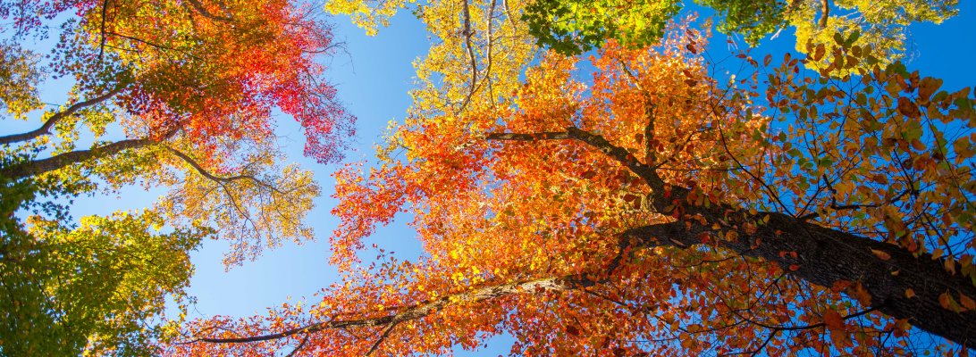
As a landscape photographer, I enjoy capturing the visual “fruits” of every season. And as much as I love winter weather, I look forward to the annual “greening” that spring provides. While winter landscapes can be beautiful, they can be extremely difficult (and sometimes downright dangerous) to capture. For this reason, summer is one of the best seasons to capture visually appealing landscape photography.
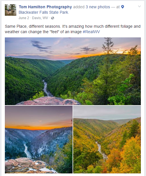
See an interesting scene that you’d like to shoot, but don’t have time that day? – Come back in a week, or wait a month until the lighting conditions are just right, no problem! Unlike in Autumn, where if you come back 2 days later the leaves may be gone, there is a greater degree of flexibility. While fall is without a doubt my favorite season, one miscalculation could make the difference between getting a perfectly lit vibrant shot and something that just looks brown and downright “Meh.” As I had posted on my facebook page, the difference in foliage can affect an image greatly:
With the impending “brownout”, I plan to make the most of the next 2 months and look forward to shooting the vibrantly colored hillsides to come. One thing for sure though, I certainly won’t miss dripping sweat all over my camera equipment!
It’s a place that I’ve always heard people talk about visiting, but I’ve never made it a priority to do so. Partially because of the stifling heat and partially because of other people’s accounts of seeing “someone not able to handle their liquor on Bourbon Street.” Added to that were the terrible images that saturated the newscast after the disaster that was Katrina. I never gave the state a fair chance, and I’m here to make things right. Not because I’m sorry; I’m entitled to my own opinions afterall. Instead, it’s because Louisiana is truly a special place. It’s not often that you find a place that has such an incredibly rich culture and such beautiful spaces.
“Sportsmans paradise”, the state motto emblazoned on license plates, is absolutely the truth. The wealth of wildlife in this state is incredible. I can’t recall seeing a place so rich in so many different species of birds (of all sizes colors and varieties!). The state even has it’s own subspecies of black bear, which I didn’t happen to see. Additionally, the wetlands in this state are a true national treasure. Spanish moss draped oaks, cypresses, and tupelos line the waterways creating a natural “cathedral”. What the area may lack in hills/mountains, it more than makes up for in beautiful trees and plants. The area has it’s own iris that adorns the banks of many bayous. -If you have a camera, find someone with a boat – you will be impressed!
Early morning sunlight shinging through the oaks in New Orleans City Park
Sunset at Lake Martin
Louisiana Irises in the Bayou
Louisianans are proud people in part due to their incredibly rich culture. Many people came from incredibly difficult situations with very few materials possessions and made a living for themselves. The state is incredibly prosperous due to its vast energy resources, productive agriculture, and strategic trading location at the mouth of the Mississippi. The state’s vast pride and wealth shines through in it’s numerous structures.
“Born Free” – Many cajuns are fiercely independent…through their struggles they’ve earned it.
Old Louisiana State Capitol
Deep South
Old buildings in the French Quarter
Cornstalk Fence
Typical French Quarter balcony
Oak Alley Plantation
A crescent moon sets over Oak Alley Plantation
The flags that have flown above Louisiana fly above the main hall in the state capitol
“Gotham City” – Refineries line the Mississippi above New Orleans
Oil refineries and other “industrial plantations” have replaced traditional plantations as the main “cash cows” in the area. Louisianans are fortunate to have well paying job opportunities that don’t require a college education.
Speaking of structures, it’s impossible to ignore the area’s numerous churches and cemeteries. Some of the prettiest churches that I’ve seen anywhere are housed here, having been built years ago. The strong faith of the locals is visible to this day…we arrived in Lafayette the day before their new bishop was to be installed. There were local TV news crews and enough flowers to fill a small floral distribution center.
New Orleans’ Jewish Cemetery: one of the more unique cemeteries that I’ve been to
Old Catholic Cemetery surrounded by a Union Carbide chemical plant
In addition to having a strong culture, the people are truly a kind and sociable people. One of the best experiences that I enjoyed while here was shooting alongside a very talented local photographer, Andy Crawford. Two months before visiting Louisiana, I contracted Andy to ask him where I could find some places to shoot some local wetlands. To my surprise, Andy was so happy to help that he volunteered to take a day off of work and take me in his truck/boat all over Southern LA. I was able to experience several areas through the eyes of a local, who shared the same passion for creating great images as me. In addition to picking up new photography skills, I picked up a new friend…That’s something that doesn’t happen everyday and a better takeaway than the great images that I created.
Andy pulling up the anchor after shootign in lake Maurepas
Early morning skyglow above lake maurepas
Moss dangling from oak branches above Bayou Portage
I’ve hinted in the past that while the vibrant “organic” colors that Spring through Fall bring make for amazing photographs. However, there is something to be said for the simple beauty of winter. After all, the peaceful beauty that freshly fallen snow (let alone the peaceful silence of being out in the snow as it quietly falls) makes for great images.
While winter may have gotten off to a late start here on the East Coast, it made for some great photography: bringing the foggiest December on record to the Mid Atlantic. Then in January, we were treated to a true whollop of snowstorm, bringing 34 inches to my backyard. Some areas of West Virginia saw 40+”! Unfortunately, this much snow made it extremely difficult for me to get to get to scenic locations to photograph, but my new pair of snowshoes got a lot of use for a week 🙂
Finally, we were able to make it up to Canaan Valley in the high Alleghenies of West Virginia for Winter’s last true stand. While not quite as cold or beautiful as the winter of 2015, all-in-all winter 2016 did not disappoint.
Cheers!
-Tom
Blackwater Canyon in West Virginia
Starry night sky above Canaan Valley
Late day sky glow in Canaan Valley
Elakala Falls
Frozen rocks at Great Falls during a cold snap
The sun trying to poke through the clouds on a foggy morning
Reston during the blizzard
I was out during the peak of “blizzard conditions” and was impressed by the amount of snow blowing around
The neighborhood…more snow still had yet to come
Saint Mary’s Wilderness – George Washington National Forest
Bolivar Heights – Harpers Ferry. The mountains were completely obstructed by the fog bank pouring over them
Sunrise in Jefferson County, WV. Due to excessively warm/moist conditions, the grass was abnormally green for late December
Jefferson County, WV
Industrial Grittiness – Halltown, WV
North Landing River Preserve, Virginia Beach
North Landing River Preserve, Virginia Beach
North Landing River Preserve, Virginia Beach
North Landing River Preserve, Virginia Beach
North Landing River Preserve, Virginia Beach
North Landing River Preserve, Virginia Beach
North Landing River Preserve, Virginia Beach
A near full moon over Back Bay National Wildlife Refuge
When I think back on many of the best moments of my life, several common denominators can be observed. One of the most typical of these is the type of places that these occurred.
My family has always seeked out places of natural beauty for our vacations and other recreational pursuits. I certainly continue this legacy, as I am always heading out to some beautiful place to pursue my latest photographic or hiking pursuit. Since meeting my wife, we have planned vacations that centered around places like this. Lucky for us, some of the most spectacular scenery to be found on terra firma is right here at home and it’s open to us all.
Whether it was combing the surf battered rocks of Oregon’s coast or craining our necks to see the canopy of a virgin redwood forest, most of these moments occured on American public lands. We are fortunate that our country was expanded and settled in a time when awareness and respect for the natural environment wasn’t far off in the future. Even more so that we had visionaries like Gifford Pinchot, Teddy Roosevelt, John Muir, Thomas Moran, and countless others influencing/creating national policy towards our wild treasures.
We hear a lot about what has made our country great in terms of our economy and our tenacious defense of liberty. Our beautiful (and plentiful) public lands are one of the things that sets us apart from other countries. Achievements like creating the world’s first national park and the Wilderness Act of 1964 have made us a worldwide leader in the preservation of earth’s natural treasures.
Below are some of my favorite memories created on our public lands:
View from the Iwa Jima Memorial – Netherlands Carillon
Siuslaw National Forest, Oregon
Looking north along the Allegheny Front
Isabelle Glacier – Roosevelt National Forest
Indian Peaks Wilderness – Roosevelt National Forest
Harpers Ferry National Historical Park
Monongahela National Forest
North Fork Mountain – Monongahela National Forest
Spruse Knob – Highest Point in the Mountain State – Monongahela National Forest
Milky Way over Spruce Knob Lake. Located deep in the mountains, the Allegheny Highlands boast some of the darkest skies in the Eastern US
Shenandoah National Park
Shenandoah National Park
Tidal Basin – National Mall & Memorial Parks
Ft. Moultrie – Ft. Sumter National Monument
Charles Pickney National Historical Site, South Carolina
Congaree National Park, South Carolina
C&O Canal National Historical Park
View from the Lincoln Memorial
At the top of Mt. St. Helens – National Volcanic Monument – Gifford Pinchot National Forest
Trail up the South slope of Mt. St. Helens. On my way to the summit, below the treeline
Great Dismal Swamp National Wildlife Refuge
Moonrise over Crater Lake National Park
Blue Ridge Parkway, Virginia
South Umpqua River – Umpqua National Forest, Oregon
For week’s I’ve debated on how to sum up/write about the areas of Chile that we visited outside of Patagonia. For a country that stretches 4,300 Km in length, with climates ranging from the driest desert on earth to the third largest glacial ice field on earth, it is hard to sum it up by just visiting two regions.
While we spent nearly 2 weeks exploring some of the best sights that this wonderful country has to offer, I feel that we barely scratched the surface. What I can say is that modern Chile has a lot to be proud of: a stable government, South America’s strongest economy, friendly people, an embrace of their history, wonderful traditions, and great food…There is nothing quite like a Chilean sandwich anywhere else on earth!
I think one of the things that I like the most about Chile is the immense pride that their people have in their country. Driving down any road, there are bright Chilean flags flying outside of just about every house. While at a bar here, the native Chilean bartender was trying to one up his Argentinian coworker by crafting a perfect cocktail. I have to admit he did a good job…It was probably one of the most beautiful drinks I’ve ever drank.
As passionate as Chileans are about their country, they are passionate about religion. It is impossible to talk about the history of Chile without involving Catholicism. The biggest crowds that we saw while in the country were gathered around churches and religious monuments.
We were fortunate enough to experience Chile’s culture in the sprawling capital of Santiago and the nearby coastal city of Valparaiso. Each of these cities is unique and it is easy to tell that Santiago is the economic and political powerhouse of this part of South America.
While Santiago packs in the masses and serves as Chile’s economic & governmental capital, Valparaiso packs in the charm. Some have called it the San Francisco of South America. The great thing about this city is that it has garnered enough attention to preserve the unique buildings, but not enough attention to ruin the unique local culture. Walking down the streets in Valparaiso is like walking through a history museum turned art museum. Photographic opportunities abound around every street corner…


")

")


")
")
")


")
")
")
")
")
")


")
")
")
")
")
")
")
")
")
")
")
")
")
")
")
")
")


")
")


")
")
")
